Friday 6 June 2008

The Sologne, June 2008

With the weather deteriorating again, we headed south and west through the Sologne. This intimate but large area of hundreds of small, man-made lakes, reedbeds, wet heath and grassland, scrub and woodland is broadly little visited apart from honeypot sites such as Chambord (more on this later). Unfortunately, it is also not an easy place to explore as much of the land is private with few footpaths, and viewing and tends to be restricted to the roadside. Having said that, it remains one of my favourite areas in France due to its tranquility - the Sologne's quiet back roads are ideal for cycling.

Classic Sologne habitats: reed-fringed lake enclosed by scrubby
woodland at Ciran (photo by phileole via Creative Commons)

As we threaded our way the region, we stopped regularly on the side of the road - often in the drizzling rain -  to check out areas of pasture, farmland and open water. With no more effort than this, we picked up Whiskered Tern (a personal favourite), Little Tern, Turtle Dove, Cuckoo, Grey Partridge and two Coypu.

Heading towards the brighter skies in the west, we hit upon a great campsite just south of Cheverny, Camping les Saules,with great facilities including table tennis and bike hire and found a great pitch overlooking a small lake. We took advantage straight away of the bike hire for a late afternoon ride around the deserted roads and tracks out towards nearby Pöely (see photos below). Despite ominous clouds, we enjoyed a leisurely ride and some great birdwatching, with StonechatLinnetYellowhammer, Cuckoo, a pair of Lesser Spotted Woodpeckers at their nest and a white-rumped Harrier species at long distance.


It stayed dry for the rest of the evening and we managed to sit out by the tent for dinner, overlooking the lake,  and later got out the bat detector although there wasn't much around. We did see some wildlife, however, with a Hedgehog snuffling its way right up to us after dusk!

The following morning we retraced some of our bike ride in the car, keen to get a look at the Lesser Spotted Woodpecker nest with the telescope. We had fantastic views of the visiting parents and at least one chick near the edge of the hole. A Cirl Bunting was nearby and a Little Owl perched on a house roof allowed us to approach quite close.

Chambord château and a herd of Wild Boar on the hunting estate

We stopped in Cheverny for a bakery breakfast and a peer through the gates at the charming château before heading off to an even more beautiful one: the royal château at Chambord, the largest in the Loire valley and one of the most recognisable buildings in the world, built by François I as a hunting lodge! Whilst the house itself is most impressive, Heather and I had visited before and today was about exploring the estate a little and (for Heather) visiting the stables and taking in their horse show. The estate itself - still a hunting reserve and home to deer, boar and much other wildlife - is very large at 54 square kilometres; the western part is crossed by four trails, bike hire is available and there are three observation towers from which to watch the animals and birdlife between dawn and dusk. Chambord is truly an all-day visit and was a great way to spend our last day in France.

Thursday 5 June 2008

Eastern Loire Valley, June 2008


Islands, sandbanks and fortified bridge over the Loire at La Charité-sur-Loire

We reached the Loire at La Charité-sur-Loire. I'm sure the Loire Valley needs no introduction: 170 miles long, bordered with historic towns, vineyards and chateaux and known as the "Garden of France" due to to the abundance of fruit orchards, asparagus, artichoke and cherry fields, the valley offers a combination of lovely scenery, fascinating history, great architecture and diverse wildlife. It was inscribed as a UNESCO World Heritage Site in 2000.

The river is also regarded as Europe's last wild river. The riverine landscape is highly dynamic, with erosion taking place, new channels and oxbow lakes forming, and islands and sand banks shifting. Wildlife interest is high, with migrating salmon and birds, a wealth of plantlife and even European Beavers, reintroduced here in 1974. We planned to take a couple of days exploring along the river to my favourite part of the valley - the Sologne, near Blois.

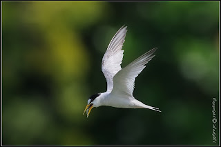
Little Tern (photo by Andy Li via Creative Commons)
Heading north from La Charité-sur-Loire, we were straight away into the Val-de-Loire Nature Reserve. From the D7, we explored two viewpoints on dead-end roads in La Chapelle-Montilard, the first in the village of Passy and the second on Vauvrette road. The first revealed little but the river and farmland at Vauvrette proved far more interesting. A stroll along the tarmac riverside track, the lève de Loire, brought us Sand Martins, Marsh Harrier and a steady stream of feeding Little Terns up and down the river. The wooded fringes of the farmland had Red-backed Shrike, Cuckoo, Kestrel and Buzzard.

Heading north, we stayed as close to the river as possible, mostly using smaller roads. We stopped at a few other viewpoints - I liked the areas near Saint-Satur (great views from the bridge on the D2) and Cosne Cours-sur-Loire. At one of the viewpoints, we found a very large, very run-over snake; it was difficult to tell, but I'm guessing it was a non-venomous Aesculapian Snake.
Photo by Anabis via Creative Commons

We didn't have an overnight stay planned but we chanced upon a fantastic campsite at Saint-Père-sur-Loire. The Hortus group site, Le Jardin de Sully, was a lovely family site with good facilities - including a small pool and table tennis - but most importantly for us it had a grassy riverside tent section with a stunning view of the river towards the town of Sully-sur-Loire on the opposite bank. Heather and I spent the evening cooking and relaxing with the binoculars close at hand to watch the birds along the river: a Serin sang in a nearby tree, a Hoopoe flew along the bank and a Little Egret flapped lazily upstream. Even better, we awoke the following morning to the high-speed babbling song of the Melodious Warbler in the tree next to our tent!

View from Le Jardin de Sully campsite towards Sully-sur-loire

From Saint-Père-sur-Loire, we headed slightly north and away from the river itself towards the Forêt d'Orléans. This vast wooded area - including the largest state forest in France - is also extremely flat and, combined with the impermeable soil, this has encouraged creation of an abundance of ponds and other wetlands, although the forest has been significantly drained in parts since the nineteenth century. Mainly oak and Scots Pine, the forest is home to Booted Eagle, Goshawk, Buzzard, Honey Buzzard, Black Woodpecker, Middle Spotted Woodpecker, Woodlark, Dartford Warbler, Nightjar, Golden Oriole, Western Bonelli's Warbler and Hawfinch. Wild Boar, Red Deer, Roe Deer, Red Squirrel are also present and Marsh Frogs (the largest frog native to Europe) can often be heard as well as seen in the wetter areas. The extensive forest rides are very attractive to butterflies and Glanville Fritillary, Marsh Fritillary, Small Pearl-bordered Fritillary, Swallowtail and Wood White may be seen.

In addition, after an absence of more than 40 years, Ospreys returned to breed on the lakes in the forest - one of the few places on the French mainland where they do so - and today there are around 22 pairs. We headed to the observatory on Étang de Ravoir. Halfway between the towns of Les Bordes and Ouzouer-sur-Loire on the D952, a gravel forest track heads north into the forest; there are clear Observatoire signs at the entrance. After a couple of kilometres there is a car park and a well-signed route through the woods to the hide which only takes a few minutes.

Osprey at nest (Photo by Shanthanu Bhardwaj via Creative Commons)

When we arrived, the female Osprey was on the nest and we had good views with the binoculars from the hide. A Grey Heron was fishing and Cormorants diving in the lake, otherwise things were relatively quiet. After contentedly watching the Osprey for a little longer, we headed back to the car, enjoying the woods a little more this time, especially the ponds and their dragon and damselflies. We stopped for another walk in the forest near Les Bordes and were rewarded with a singing Nightingale, a flyover Cuckoo and circling Buzzard.

With more camping beckoning in the Sologne, we decided to spend the night in the dry in Orléans, the ancient city that is capital of the Loiret department and the Centre region. Dating back to Gallic and Roman times, Orléans' strategic importance as a crossing point over the river made it, alongside Paris and Rouen, one of the three richest cities in medieval France and it was here in 1429 that Joan of Arc won her first major military victory in the Hundred Year's War between France and England.

We stayed at the charming and well-located Hôtel de l'Ambeille and wandered down to the Gothic cathedral and outstanding Fine Arts Museum. After a stroll down by the riverside, we had an excellent dinner at La Petite Marmite in the old quarter.

Joan of Arc statue, Place du Martroi, Orléans
(photo by Joachim Fenkes via Creative Commons)

Friday 30 May 2008

The Morvan, Burgundy, May 2008 (2): Regional Nature Park

Classic scenery of The Morvan Regional Nature Park
(photo by mcbardin via Creative Commons)

The superb Morvan Regional Nature Park (RNP) is a large area: 173,000 hectares (427,000 acres), equivalent to the size of the Yorkshire Dales or more than three times the size of the New Forest. Leaving behind the plains of the Champagne region and driving south into this granite massif, comprising half dense woodland and half pasture, makes it clear just what a special place this is: the heavy rainfall feeds lush vegetation, five huge lakes and the rivers and tributaries of the Yonne and Cure rivers all set in an intimate, rolling landscape that is home to bountiful wildlife and fantastic areas to walk, ride and relax.

Our visit started at the Maison du Parc in Saint-Brisson, on the D6 road just north of Taureau lake. The centre has a number of different areas looking at different themes: the Ecomusée has interactive displays taking you through the development of the landscape with its people and wildlife; a Tourism Centre has the usual information on walks and attractions; and there is an attractive arboretum and garden area.

Meadows of orchids near Saint-Brisson, The Morvan RNP

The area that kept most of our attention, however, was the Museum of the Resistance. From 1940, the Maquis - the predominantly rural guerilla bands of the French Resistance - made extensive use of the Morvan in the Second World War, using its difficult terrain and isolation as a refuge from and to counter attack the occupying German army. Aided only by Allied parachute drops of food and equipment, the Maquis liberated most of the region in 1944. Nonetheless, many villages were destroyed and arrests, deportations and executions were common occurrences. This museum remembers this painful period with photographs, film, uniforms, weaponry, propaganda and even poetry, with audioguides in English, French and Dutch.

With the weather reasonable, we chose one a 90 minute walk starting from the Maison du Parc to stretch our legs. This took us west of the village along green lanes through woodland, wet grassland and meadows. The scenery is beautiful: creamy-coated Charolais cattle graze the pastures and wild flowers coat every field and verge. The birdlife was lively, with Red-backed Shrike seen and a Garden Warbler entertaining us with its varied song. As we returned past lake Taureau, a Black Kite glided over the water and above us.
Saint-Brisson, Morvan RNP, Burgundy

Keen to get further into the park, we moved from our hotel in Vézelay to camp at Lac des Settons, 50km further south. Arriving at the pleasant Camping Plage du Midi in time for dinner, awaiting us was horribly wet weather and one of those evenings when you really don't want to be in a tent!
Lac des Settons, by Akial via Creative Commons


The rain eased off the following lunchtime long enough for us to explore tracks east along the shore and into the nearby country through meadows and wet woodland. A Hoopoe kept our spirits up, its song reaching us nearby before we were able to watch it fly over us and away across the fields.


Unfortunately the rain returned later in the afternoon and we took advantage of the campsite's covered outdoor area for drinks and cooking. An inquisitive Common Redstart was a constant companion. However, with more wet weather forecast, we decided to move on again to the Loire Valley.

Thursday 29 May 2008

The Morvan, Burgundy, May 2008 (1): Culture in Vézelay & Saint-Père

The view south from the top of the "eternal hill" at Vézelay

Heading south-west from Forêt d'Orient, the wet weather stayed with us all the way to Burgundy. A couple of hours drive across country took us through lovely scenery, Chaource village (don't forget to stop for the fantastic local cheese) then across the border into the Yonne department and the town of Chablis. Here we saw some sun and stopped for a glass of the local produce, followed by a wander round some of the many cellars for tasting. A stop at the Domiane Vocoret cellar on the D235 on the way west out of town saw us pick up a case of their Forêt Premier Cru.

After an enjoyable but showery exploration of Auxerre's cathedral and riverside, we headed for the ancient town of Vézelay on the edge of the Morvan Regional Nature Park. Founded in the ninth century with a monastery atop a prominent hill with inspiring views, the town lies on a major pilgrim route to Santiago de Compostela in Galicia, Spain.
Looking up to the monastery & basilica at Vézelay
(photo by Heather)

In the tenth century, the town's monks brought relics of Mary Magdalene to the town from southern France, leading to a further influx of pilgrims that continues to this day despite the fact that later discoveries in southern France undermined Vézelay's position as Europe's main Magdalen shrine. In the magnificent Basilica of St Magdalene, built in the 11th century, you can visit the crypt where the Vézelay relics still reside. The town and the basilica are today a UNESCO World Heritage Site.

The Basilica of St Magdalene (Basilique Sainte-Marie-Madelaine), formerly Vézelay Abbey: on the left the exterior facing the town, on the right the beautiful Romanesque nave.


The town itself sits around the foot of the hill and winds its way to the top along narrow streets often thronged with visitors during the day. If you are just visiting, it is definitely best to park at the bottom! My Alfa 156 scraped its way up to the top and our hotel, the charming Les Glycines.

Downhill along Rue des Écoles, Vézelay


As the afternoon draws on and the buses depart, the town quietens considerably, leaving just those staying overnight to enjoy the evening views and some good restaurants. From our two nights here, we can recommend the food and service at the Hôtel de la Poste et du Lion d'Or - especially the local cheese board! They have a well-priced set menu.


Vézelay made a great base to explore the north of the Regional Nature Park - more on that in the next post. But, continuing the theme of history and culture, the nearby village of Saint-Père (sometimes written as Saint-Père-sous-Vézelay) and a local archaeological site are well worth a visit.

In 1934, whilst searching for the potential site of King Arthur's battle at Valbeton along the River Cure, Professor René Louis discovered a ruined Celtic temple and Gallo-Roman baths on the same site, both linked to the heavily salted mineral springs found here and known today as Les Fontaines Salées. The use of the site goes back to Neolithic times as a place of worship and one of the most important healing sanctuaries in Gaul.

The Roman baths at Les Fontaines Salées, with the water channels (above)
and remnant suspended floor (below right) still clearly visible

The oak 'pipes' used to create the wells were hollowed out by fire and date to around 3000BC. As well enjoying the soothing properties of the water, the site users collected the high salt content through evaporation for food preservation and tanning. But whilst the slow bubbles clearly visible in at least one well were presumed by the Celts to be the spirit of the Gods, today we know it is in fact natural helium gas. A handpump is located on one well so you can taste the water - I can't recommend it (left)!
This is a peaceful and well-cared for site, with good interpretation and maps (albeit in French). We were the only visitors on a Thursday afternoon. The River Cure flows lazily nearby, bordered by an avenue of tall poplars. The site is also a haven for wildlife: in addition to the numerous Marsh Frogs that were sunbathing in the springs (below, photo by Heather) and Common Lizards bathing on the stonework, a Golden Oriole was singing from the adjacent wood and a Black Woodpecker swooped between mature trees.


The nearby village of Saint-Père has a small museum that houses all the finds from the site - mainly ceramics, coins, jewelry, statuettes and religious offerings - since excavation began in 1935 and is worth a quick stop after your visit to the site. The village's gothic church dates from the thirteenth century, has a 50m high bell tower and also merits a look.

Sunday 25 May 2008

Forêt d'Orient, Champagne-Ardennes, May 2008

Forest track through Forêt d'Orient Regional Nature Park

Late May and early June of 2008 saw Heather and I camping around various regions in northern and central France in the vain search of anything but rain... Whilst we didn't find much sun, we did discover some fantastic new areas to explore - the first of which we have returned to in both 2009 and 2010.

Initially heading for Burgundy on our first day, on impulse we stopped late afternoon in the Forêt d'Orient Regional Nature Park to make the most of what turned out to be the best weather of the holiday! The reserve - covering 70,000 hectares (173,000 acres) and consisting of three reservoirs nestling in dense oak forest -  is a great destination for the walker or cyclist seeking a quieter area and wildlife.

Lac d'Orient (photo by Gerald Laik via Creative Commons)

With the summer season just starting, the area was certainly quiet and we joined just a handful of other tents on the well equipped L'Epine Aux Moines campsite at Géraudot. Just a two minute walk from the shore of Lac d'Orient, a pizzeria and cycle hire, the site also lovely views north along the boundary of the forest. On a lovely sun-drenched evening, we sat and watched Turtle Dove and Red-backed Shrike amongst commoner species and a Golden Oriole regaled us with its beautiful, flute-like song early the next morning.

Whilst the weather started to deteriorate from the start of day two, we were determined to make the most of a hard-earned break. The cycle hire was very reasonably priced and the bikes of good quality. France is renowned as a cycle-friendly country, and the Tour des Lacs cycle path was smooth and scenic, taking us along the shores of Lac d'Orient, Lac du Temple and Lac Amance to the town of Dienville before returning through the forest, most of the entire route off-road. A shorter forest-only route is also possible for kids.

The author pauses for breath on the cycle path along the shore of Lac du Temple


The tour is a fantastic way to see the park and even the short sections along the D43 and D50 roads were reasonably quiet. The reservoirs are all man-made (Lac du Temple and Lac Amance were constructed as recently as 1990), created to regulate waterflow and flooding on the Seine river and to supply drinking water to Paris, but they are naturalising nicely with nice emergent vegetation and lots of scrub. Waterbird populations are tremendous in winter - in fact, along with Lac du Der-Chantecoq to the north, the area forms probably the best winter location for birdwatching in northern France; read more here - the lakes were still busy with Coot, Great-Crested Grebe, Mallard and Common Tern whilst the shoreline rang with birdsong, with the magnificent Great Reed Warbler seen a couple of times atop the reeds. At Lac Amance, from the hide at the north end of the western shore, we were lucky enough to see a Little Bittern and Temminck's Stint. Otter and feral Coypu (an introduction from South Amercica) can also be seen here, the latter often at very close quarters.

Perhaps even better than the lakes is the deep oak forest. France's woodlands are normally well-managed for timber and this area is no different, but the size of the forest means that the operations do not have a major impact and wildlife simply moves around as necessary. The woodland harbours six species of woodpecker: the British three - Great Spotted, Lesser Spotted and Green - plus the noisy Middle Spotted, shy Grey-headed and leviathan Black, the largest woodpecker in Europe and Asia at 18 inches high and approaching three feet in wingspan. Deer are common sights and - if you're quiet when you hear a rustling in the undergrowth - a Wild Boar might make a guest appearance.

Black Woodpecker and chicks at the nest,
by Alistair Rae under Creative Commons licence

Pedalling through the forests, it's easy to get caught up in their primaeval atmosphere: a Red Deer stag crossed the track at a run in front of us, woodpeckers drum and call and, in every direction, never-ending woodland rides stretch away from you. We followed the main surfaced tour route along the Route du Temple but there are hundreds of miles of forest paths to take advantage of - maps and walk leaflets are available from the Maison du Parc (visitor centre) at the junction of the D43 and D79 on the eastern edge of Lac d'Orient.

Monday 28 April 2008

Ullswater steamer walk, April 2008: Howtown to Glenridding

Glencoyne from Silver Point, Ullswater

A grey Sunday morning in late April saw the usual Lakes crew taking the Ullswater steamer from Glenridding to Howtown for a wonderful low-level walk around the lake. The day before we'd had to abandon an attempt on Blencathra just below the start of Sharp Edge due to thick fog but still had a long, tough walk and this combination of boat ride and stroll was the perfect morning-after cure.

We arrived at the pier early for the 9.45am steamer. No bad thing - we drank coffee from the café and watched Swallows, Swifts, House and Sand Martins circling over the water whilst a pair of Oystercatcher fed on the shingle shore opposite. 

By Ennor under Creative Commons licence
From Glenridding, we took the steamer north up the lake. The low cloud and complete absence of wind created a surreal atmosphere, and we had some fantastic views of both shores as well as a close encounter with a pair of Goosander.

Sandwick Bay from the water, Ullswater

Just over 1 kilometre from the pier, on the eastern shore, lies Silver Point. This is a fantastic viewpoint and one that got well-used by our group on the walk back, for lunch and photos.

Silver Point from the water, Ullswater

Coming into Howtown: Waternook

After 40 relaxing minutes we steered into Howtown harbour. The steamer goes on to Pooley Bridge but we left it here for the 5.5 mile (9km) walk back to Glenridding. The route follows a narrow road around the edge of the bay before turning off onto a path that goes behind Waternook (see photo above) and runs beneath Hallin Fell along the shore, both in the open and through Hallinhag Wood. Male Willow Warblers were singing their melancholy descending cadences and other small woodland birds - Blue Tits, Great Tits, Chaffinches, Robins and a Wren - were often calling or flitting across the path. On the lake beside us, eight Canada Geese and pairs of Mallard and Mute Swan kept us company.

Past Sandwick Bay and Beckside Farm, the path stays inland for a kilometre or so. Approaching Low Birk Fell, Scalehow Force waterfall comes into view away to the left, and a short climb up the beck allows you to see the falls. Along Birk Fell, there's another beautiful stretch of birch woodland here; more Willow Warblers were calling and two Lesser Redpoll perched in a tree on the shore, allowing fine views. After stopping to let about twenty mountain bikes past - we only saw a handful of other people on the whole route - we headed on again for Silver Point and stopped for lunch and photos overlooking the lake.
Birk Fell from Silver Point

Glencoyne and boats from Silver Point, Ullswater

Silver birch, Silver Point, Ullswater

From the point, we headed south on the shore side of Silver Crag to the foot of the lake and took the footpath across Side Farm to Patterdale. From here, it's just over 1 kilometre along the road to Glenridding and the completion of a fantastic walk.

Tuesday 1 April 2008

Welcome to our trip reports blog

Looking down Great Langdale from Stickle Tarn, Lake District, UK

Welcome to the travel blog of the Wild Future team (www.wildfuture.co.uk).

Most of the time, we'd rather be doing it than writing about it. Sometimes, we get away from our desks and breathe some fresh air.

We prefer to use our own experience as much as possible for our recommendations and the Wild Future trip reports in this blog give all the dull, dirty detail about the time we spend in the field. We hope they come in handy for inspiration for your own trips or at least show where not to go! Steve apologises for the amount of birdwatching involved...

Any questions about the trips, just email us at info@wildfuture.co.uk.

Steve & the Wild Future team